Putting Food Access Resources on the Map
Members of HCP-MV and Community Partners Plot Out Food Access Locations to Show Residents and Social Service Organizations Where to Go to Get Good Food
The Mahoning Valley has been pinned on the map, so to speak, for a lot of things over the years. Unfortunately, some of these recognitions are less than glamorous, especially when the focus is on the health of the region.
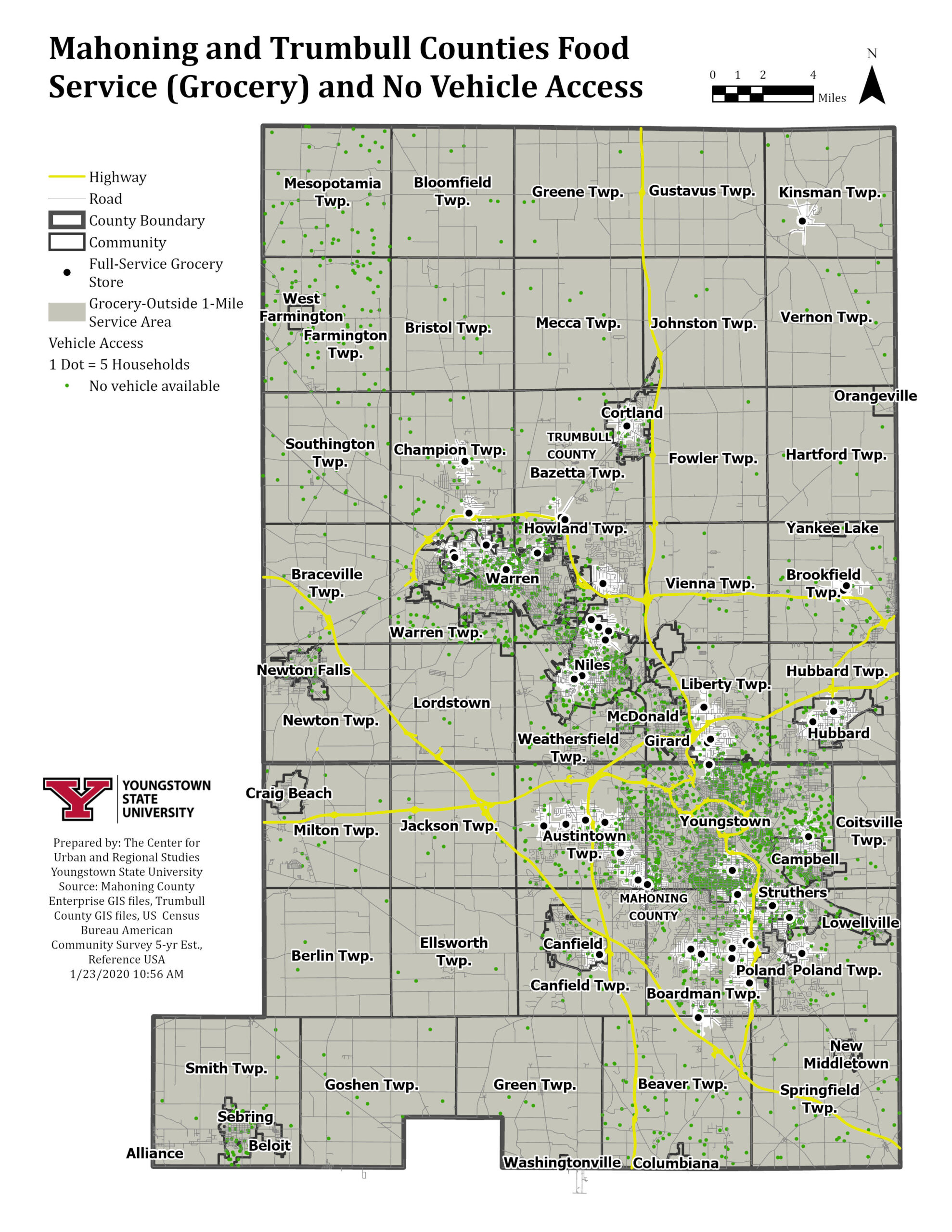
Map from YSU CURS showing grocery store locations and households with no vehicle access in Mahoning and Trumbull Counties.
A 2018 report from the Food Research Action Council (FRAC) entitled, “How Hungry is America?,” found 22% of all households in the Youngstown-Warren-Boardman metropolitan area struggled to buy enough food for themselves and their families in 2016 to 2017. The food hardship rate for households with children was at 34.8%, compared to those without children at 16.6%. As a result, according to this the results of this report, the Mahoning Valley Ranks #2 in the entire country for families facing food hardship. The cities of Warren and Youngstown both struggle with accessibility to healthy foods and fresh produce as grocery stores have disappeared due to persistent population and economic decline. Stores that were once located in neighborhoods have long been shuttered and shipped out into neighboring communities, out of reach for many families.
Even though the Mahoning Valley has had to weather some pretty scary storms over the years, including this most recent unexpected COVID-19 crisis, the region has found a way through as long as we have a little help from our friends. Just in the last 4 months during the COVID-19 pandemic, there have been countless stories of organizations stepping up to help each other help residents facing a downpour of challenges resulting from the closing or dramatic disruption at schools, businesses, and government services. Members of the Healthy Community Partnership-Mahoning Valley have been thinking outside of the box to find creative solutions to these unforeseen challenges that have been documented and shared.
Just as there doesn’t seem to be an end in sight for the COVID-19 crisis, there’s also no end in sight for continued collaboration.
One of the most common and crucial challenges to overcome has been finding food, which is not surprising given that food, especially healthy food, has been hard to come by for so many in the region even before the pandemic. In a story reported by WKBN, Vince Brancaccio, CEO of the Help Network of Northeast Ohio, shared that the organization “went from an average of 1,500 calls a week to as many as 2,500 during the pandemic.” An overwhelming number of those calls were from families trying to find food. Mr. Brancaccio reported that the Help Network showed a 200% increase in calls from people looking to find food pantries nearby.
To adjust to the brave new world that greeted us after the Ides of March, organizations had to quickly re-imagine and reconfigure how they operated. This dramatic increased need for food was felt elsewhere in the community. Shortly after Ohio’s Safer at Home Orders closed many businesses, schools, and social service agencies, local philanthropic organizations came together to figure out what they could do to use their resources to respond. The result was a collaborative approach to work together to respond to the needs of the community. The foundations designed a more streamlined grant process and common application, a single point of entry for community organizations to submit grant requests responding to the crisis to three potential funders: the Community Foundation of the Mahoning Valley, the Raymond John Wean Foundation, and the Youngstown Foundation.
Much like the Help Network of Northeast Ohio, an overwhelming number of requests flooded into the Community Response Fund from organizations requesting support for food focused activities. Requests for funding to support food access efforts were not new, again 22% of households in the Mahoning Valley suffer from food hardship, but seeing them come in such quantities created some questions about what support is already out there and where can people go to get it?
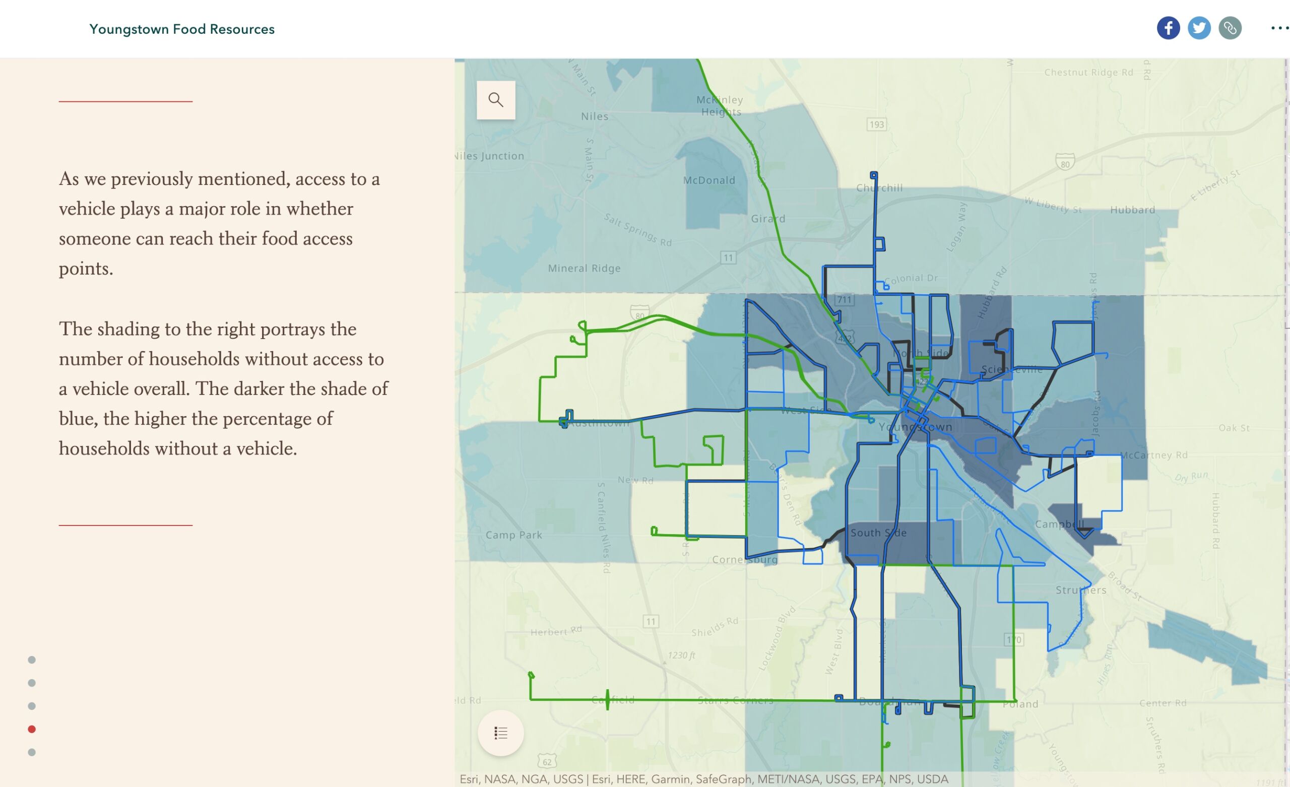
Youngstown Food Resource storymap showing households with challenge to vehicle access making it difficult to get to a grocery store.
Since the challenge of food access is unfortunately not a new phenomenon, members of the Healthy Community Partnership-Mahoning Valley have been developing tools that show and tell the story of food accessibility, or the lack thereof. One of these tools is the Youngstown Food Resources Map. Emily Miller, an AmeriCorps VISTA with the Youngstown Promise Neighborhoods, led the project and worked together with John Bralich at the Center for Urban and Regional Studies at Youngstown State University to create the storymap. The value story mapping is that these tools, like traditional maps, show where things are: where food resources are, where people are, and where bus routes are, and so on. But, storymaps also provide a narrative, a story, and context for why disruptions in access to healthy foods exist and the ways these challenges impact the lives of residents in Youngstown.
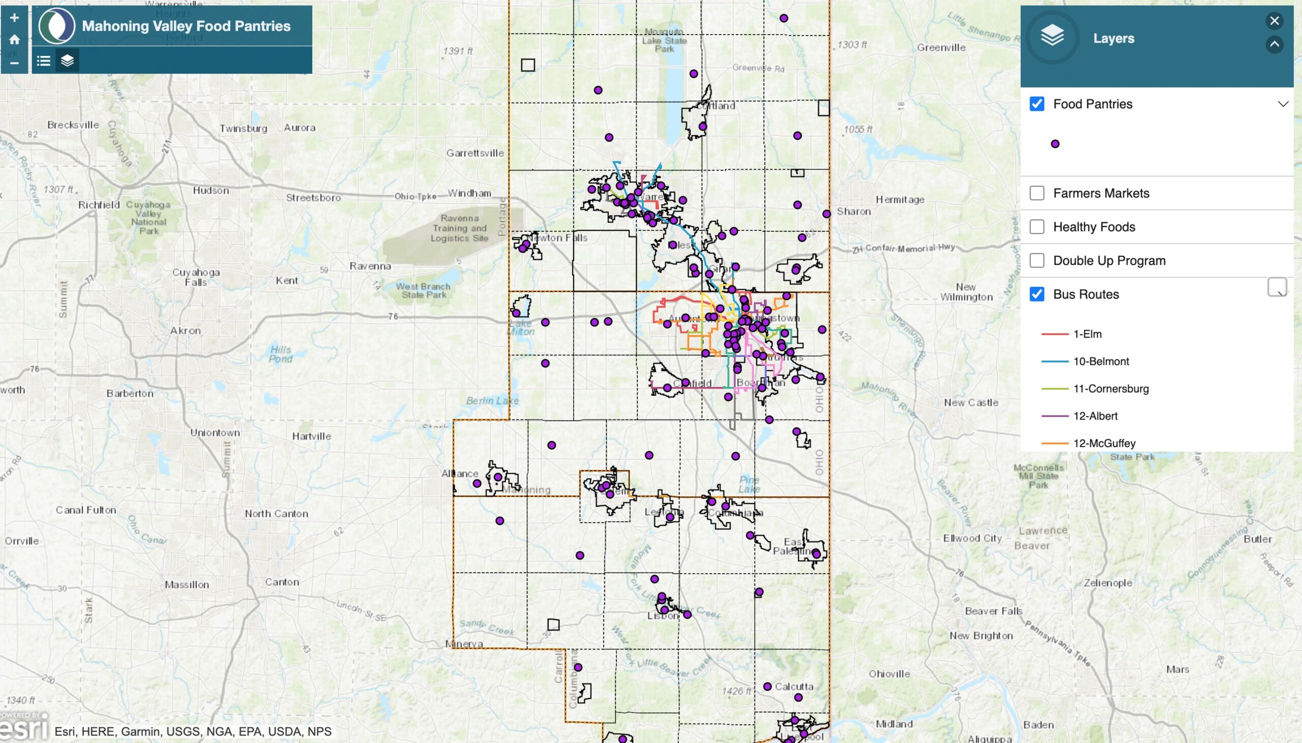
Food Pantry map created by Eastgate showing food pantry locations and WRTA bus routes.
The basic function of any map, as we know, is to show us where things are and how to get to them. After seeing the number of requests for food, the Community Foundation of the Mahoning Valley and the Raymond John Wean Foundation determined that to be equitable and strategic, they needed to know more about where current emergency food resources were. The foundations connected with another local mapping resource, the Eastgate Regional Council of Governments, who gathered data about the location, hours of operation, contact information, and so on for food pantries affiliated with Second Harvest Food Bank. This allowed them to create a map that visually displayed all of this information that has been collected and catalogued by the Help Network over the years in their extensive database of community resources.

Mahoning Valley Food Access Resource Map currently showing locations of food pantries, farmers markets, grocery stores with SNAP Double Up, “c-stores” with healthy foods, WRTA bus routes, and sidewalk access.
Many may have heard or read the quote, “A tool is only as good as the team using it.” These mapping tools are great resources but only if they are available for those who need to use them. The final leg of the journey for what has come to be known as the Mahoning Valley Food Access Resource Map (FARM)—pun probably intended—was completing the circuit between the resource providers, the resource mappers, and resource users. The two maps were shared with staff at the Help Network of the Mahoning Valley, who welcomed these new resources into their database, where they can be accessed by anyone who needs them, right now. Members of the resource development team and the Healthy Community Partnership have plans to update the map with additional food access resources like grocery stores that offer nutrition incentive programs like SNAP Double Up, “c-stores” offering healthy foods, farmers markets and farm stands, and community gardens. These resources can also be adapted into a storymap format to better tell the story and track progress on the journey to put the Mahoning Valley on the map for becoming a healthier community.